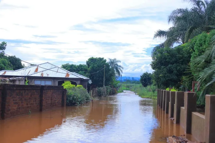
Devastating scenes in Limpopo after heavy rains led to widespread flooding, impacting communities and infrastructure.
Image: Office of the Premier: Limpopo Provincial Government/ Facebook
Last Thursday, the South African Weather Service (SAWS) escalated its warning for disruptive rainfall in parts of Limpopo and Mpumalanga to a rare Red Level 10. This rare Level 10 warning—an increase from the previous Orange Level 9—is the first issued since the KwaZulu-Natal floods in 2022.
Speaking during a SAWS podcast, SAWS forecaster Lehlohonolo Thobela explained what a Level 10 warning signifies.
“A Level 10 warning means there is a high likelihood of severe impacts expected for the area, and these impacts are expected to result in widespread damage. Could be loss of life, could be damage to infrastructure and all developments of what could be hazardous,” Thobela said.
“The main thing is that it covers a bigger area, it’s not localised. However, the main thing is that the impacts are expected to be severe.”
Thobela highlighted that with the eastern parts receiving a lot of extreme weather conditions, when they issue a Red Level 10, it is usually because of a mesoscale, and in the sense of a smaller region that usually has a system that is more localised than a bigger system.
“The last time we spoke about it, it was about heavy rain that was also expected in KwaZulu-Natal, and it was in May 2022. That’s when we issued a Red Level,” Thobela said.
However, Thobela explained that the recent Red Level was because of a low pressure system over Mozambique, that the system lasted longer in the area and it results in a lot of moisture being advected into the area.
“In simple terms, it was transported into the northeastern regions of South Africa as a whole, impacting Limpopo as well as into Mpumalanga,” Thobela said.
Therefore, the northeastern regions were receiving a lot of rain. That was due to a low-pressure system over that area.
“The reason why we increased this was because the impacts are expected to grow further than what we have expected,” Thobela said.
He explained that annually, the area receives about 800 to 1,000mm of rain. Last week, nearly half had already been observed and measured. This meant that what it would be able to contain in a year, it is pressed into a corner to be contained in about four days.
Thobela further explained that the low-pressure system was expected to die out from January 18, and will start to ease out into the 19th. However, there is still a chance of more moisture in the area. Clouds that produce rain need a lot of moisture feed.

Relentless rainfall in Limpopo has led to the washing away of roads.
Image: Office of the Premier: Limpopo Provincial Government/ Facebook
“We’re still expecting the moisture to be around the areas up until the 19th of January, and starting from the 20th, we should start seeing some clearance over those areas,” Thobela said.
“But I need to emphasise that with that happening, saying we’re expecting the system to stop by the 18th, and less moisture happening. People seem to just start having normal routines and start working like it’s normal. There will still be some work to be done to clear.”